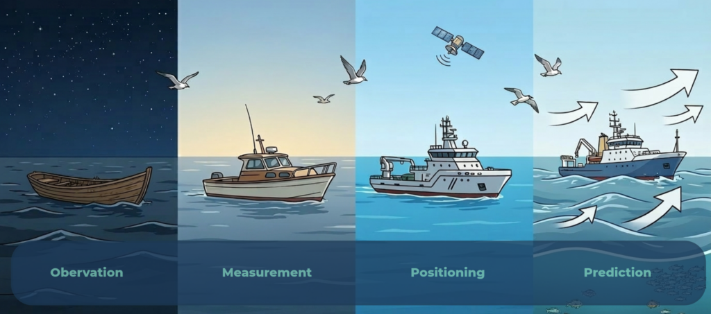
The story of offshore navigation mirrors that of human progress, from following the stars to chartered seas, satellite systems, GPS, and eventually AI.
Each innovation has pushed maritime confidence further.
Offshore navigation has come a long way from paper charts, and challenges persist. Despite digitalisation of tools and systems, fragmented data and limited forecasting abilities still hold navigation back. Today, we’re entering a new phase of navigation; powered by AI and predictive analytics that don’t just tell us where we are, but can intelligently react to what’s coming next.
So, how have the centuries of innovation got us to this point?
Let’s dive in!
The future of offshore navigation isn’t guesswork…
Explore how NeuWave’s WAVEfinder environmental intelligence suite brings precision, adaptability, and foresight to every decision offshore.
A quick history of offshore navigation
With powerful GPS navigation tools built into our handheld mobile devices, it’s easy to overlook how easy everyday navigation has become for most of us in the modern world. But for much of human history, and particularly when out of our depth at sea, this hasn’t been the case.
Centuries (and more) passed whilst humans crossed the world’s oceans with methods and tools we’d now consider primitive. Early mariners relied on coastal landmarks and celestial cues when land wasn’t in sight. The obvious problem here? When the skies aren’t clear, it’s impossible to know what lies ahead (we’ll come back to this later).
To overcome this, humans have relied on some impressive and innovative ways of mapping coasts and seas.
But the precision instruments adopted during Europe’s so-called “Age of Exploration” (around the 16th century, or about 500 years ago) revolutionised ocean navigation. The sextant, which used “Newtonian optics” to determine latitude and longitude with unprecedented accuracy, pathed the way for more complex, and more precise, navigation tools.
As a species, we’ve been charting and plotting the coasts and oceans for almost as long as we’ve been traversing them. Standardised cartography enabled shared knowledge of potential routes and hazards (yes, including sea monsters!) Not only between colleagues, but across time, as well.
The 20th century saw a shift towards digitisation in offshore navigation, as in many other industries and fields. GPS and electronic chart display systems (ECDIS) replaced manual plotting, drastically improving efficiency and reducing error. Whilst the introduction of digital data has improved routing and enabled more confident decision making, it has also shifted the practical role of the navigator.
Ultimately though, each successive leap forwards in the history of offshore navigation produced better tools, and enabled clearer environmental insight.
The rise of data-driven marine navigation
GPS advancements have improved navigators’ ability to know their exact position and better understand what lies ahead.
Modern systems and tools allow vessel operators to understand and interpret environmental dynamics in real time (and in advance) enabling decisions to be made based on real insight and actionable foresight.
Vessels are now able to gather and access continuous data on wind, currents, temperature, seabed and wave conditions, with a variety of both hardware sensors and satellite feeds.
We know more about the oceans than ever before, thanks to detailed oceanographic sampling efforts, and tireless interdisciplinary research spanning the globe. More data and more information has allowed for the development of predictive models and analytics tools offering reliable, real-time decision support.
Where historically, navigation has relied on reactive responses to changing conditions, the new generation of environmental intelligence tools fuse location, environmental, operational, and project-specific data into predictive planning. Actionable and data-led insights that can reliably inform decisions both at port and at sea.
Smarter navigation starts with smarter seas…
Learn more about how NeuWave’s environmental intelligence is transforming route planning through predictive analytics and high-resolution data.
Limitations and challenges to modern offshore navigation methods
Despite immeasurable progress, the data used for offshore navigation remains fragmented and largely reactive in nature. Certain operational challenges mean that theoretical advancements don’t always translate to real-world improvements.
The existing methods for planning and conducting offshore navigation are often limited in useful predictability beyond a few days, making long-term route planning an uncertain practice. Decisions made too far in advance are unreliable. They also often lack interoperability, restricting integration between vessels, ports, coordinators and stakeholders.
Accessible data underpins the success of our modern maritime industries. While we arguably have more data than ever, this often exists on separate platforms in “data silos”. This fragmentation of environmental data causes bottlenecks in essential (and often time-sensitive) decision making.
For the next-generation of offshore navigation tools to pose actual, real-world improvements they’ll need to address this issue head on.
In the face of increased digitisation, some human risk factors also remain. Studies have shown that an over reliance on incomplete or delayed data can still lead to costly errors, unnecessary downtime, and safety incidents. Navigators face “dashboard fatigue” from the need to consult numerous screens and sources, and being constantly reliant on multiple alerts and interfaces.
If we’ve got the data (and we do!) then the industry is ready for tools that can unify and interpret this for actionable, predictive insights and tangible results.
The predictive analytics revolution
Offshore industries have started to address these issues and face the future. Various EI and AI tools that intelligently integrate multiple data layers for smarter, more adaptive navigation are entering the market.
The use of AI to interpret historical, real-time, and forecast data simultaneously allows navigators and planners to build an accurate, reliable model of the conditions vessels will face.
But what does predictive analytics actually mean for offshore navigation? And what should you look for in new navigation tools?
- Unified decision systems: Platforms that merge environmental, operational, and performance data into a single navigational picture
- Adaptive route planning: Routes that dynamically adjust based on evolving weather, port congestion, geopolitical and environmental restrictions
- Historical trend learning: Systems that learn from past voyages and performance outcomes to refine predictions over time
- Fuel/emissions optimisation: Smarter routing that reduces unnecessary idling or detours, cutting costs and carbon footprint
- Built-in risk reduction: Predictive insights that allow operators to avoid hazards before they form, not just respond once they’ve already happened
The benefits are numerous, including financial savings, less idle time and inaccurate weather windows, and crews that are more fulfilled and less fatigued. They can spend less time manually analysing data, and more applying their expertise strategically and effectively.
From reactive to predictive; evolve with navigation…
Learn how our AI-driven environmental intelligence is helping crews plan ahead, cut fuel waste, and stay ahead of changing conditions.
On the horizon – full automation for offshore navigation?
As with driverless cars and autonomous trains, offshore navigation will trend more towards automation in the coming decades. Full automation is a long-way off, however, and will take significant infrastructure investment and updates.
The next horizon is a hybrid model, placing humans in positions of strategic oversight; with machines continuously sensing and interpreting data.
Human + machine collaboration will likely become the operational norm in offshore navigation. Rather than manually plotting courses or responding to alerts, navigators will supervise intelligent systems that propose optimal actions, and intervene increasingly only as necessary.
This concept of human-machine teaming is already being studied in cyber-physical systems and autonomous domains, with emphasis on trust, transparency and feedback loops. Dynamic awareness will underpin the user experience.
Instead of static snapshot maps, systems will deliver continuous, context-aware support; alerting crews to emerging hazards, recalibrating route plans in real time, and providing confidence or uncertainty measures for each suggestion.
Interconnected ecosystems (vessels, ports, regulators, and data providers) will share environmental intelligence in real time. Ports will broadcast vent forecasts, congestion data, and tug availability; vessels will reciprocate with voyage performance and sensor feedback. AI-powered port systems already generate digital twins to coordinate operations in real time.
But to safely reach that future, ethical and operational trust must be baked in. AI transparency, explainability, clear data governance, rigorous validation, and operator training are prerequisites for adoption. Without these, crews may mistrust or misuse AI insights.
From sextants to supercomputers, navigation has always been about foresight.With predictive analytics, environmental intelligence, and unified data systems, offshore navigation is evolving into a smarter, safer partnership between people and machines.
The horizon has never been clearer.
The era of static maps is over…
Offshore navigation that’s intelligent, adaptive, and environmentally aware. Try NeuWave’s EI solutions.